Project High resolution heightmaps for Orbiter

kamaz

Unicorn hunter
Addon Developer
Joined
Mar 31, 2012
Messages
2,298
Reaction score
4
Points
0
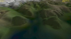
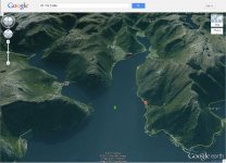
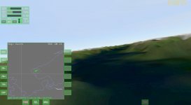
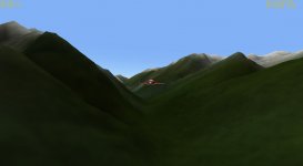
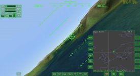
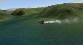
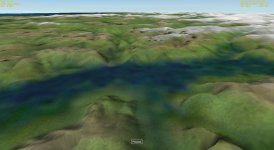
The first attachment shows a Delta Glider (that tiny red dot in the center of the image) parked on water near my old vacation spot in in Norway. The second attachment shows the same location in Google Earth. The third image shows flight over the fjord.

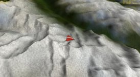
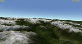
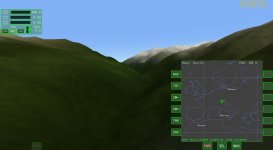
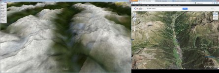
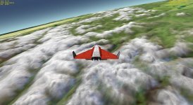
Images #4 throught #7 show flight in Alps. Comparison of results for Alps with Google Earth in image #8.

Images #1 and #3 have been gamma-corrected, because the texture is was initially too dark.

Rendered with 2010P1 + Orulex. Digital Elevation Models from http://www.viewfinderpanoramas.org. DEM resolution 3" in Norway, 1" in Alps. Texture from NASA Blue Marble (June 2004, 500m/px). Data preparation using custom Python and C code.

Compiled dataset size (3" South Norway + 1" Alps + textures) 1.1GB total.

DATASET DOWNLOAD (3" resolution unless otherwise specified):
South Norway (42MB)
 

Attachments

  • bjordal-orbiter-gamma.png.jpg
    bjordal-orbiter-gamma.png.jpg
    94.7 KB · Views: 113
  • bjordal-google.jpg
    bjordal-google.jpg
    217.5 KB · Views: 121
  • sognefjord-flight.jpg
    sognefjord-flight.jpg
    89.1 KB · Views: 81
  • 12.11.06 02-07-41 GL-01.jpg
    12.11.06 02-07-41 GL-01.jpg
    129.4 KB · Views: 83
  • 12.11.06 02-10-41 GL-01.jpg
    12.11.06 02-10-41 GL-01.jpg
    295.5 KB · Views: 227
  • 12.11.06 02-11-21 GL-01.jpg
    12.11.06 02-11-21 GL-01.jpg
    106.3 KB · Views: 67
  • 12.11.06 02-11-01 GL-01.jpg
    12.11.06 02-11-01 GL-01.jpg
    463.1 KB · Views: 57
  • alps.jpg
    alps.jpg
    187 KB · Views: 66
Last edited:
A simple color correction of the texture (gamma=1.8) does wonders.
 

Attachments

  • 12.11.06 22-21-57 GL-01.jpg
    12.11.06 22-21-57 GL-01.jpg
    114.1 KB · Views: 41
  • 12.11.06 22-22-19 GL-01.jpg
    12.11.06 22-22-19 GL-01.jpg
    72.9 KB · Views: 48
  • 12.11.06 22-24-09 GL-01.jpg
    12.11.06 22-24-09 GL-01.jpg
    130 KB · Views: 46
  • 12.11.06 22-17-32 GL-01.jpg
    12.11.06 22-17-32 GL-01.jpg
    173.2 KB · Views: 59
Guy, this is amazing. I would be happy to download these, but 1 Gb of download cannot be supported by my internet connection in relatively short amount of time ...
 
At 3" resolution, it is not that bad. A 1 deg. x 1 deg. tile takes 3MB. So the South Norway dataset (between 56N 8E and 63N 11E) takes 289MB (66MB zipped). I will try to upload it tomorrow (my uplink is 128kbit :( ).

At 1" resolution, we're talking 26MB per tile. The Alps dataset is about 900MB (and zipping does not seem to help).

Another thing to remember is that Orulex must load all DEM tiles into memory on startup, so we have the 3.5GB memory limit.

However, if we limited ourselves to covering just mountainous areas at 3" (and used a lower resolution DEM for plains), then a decent global heightmap seems achievable.
 
It is an interesting idea but as pointed out it is not practicall to cover all of Earth.

Why not do it for an island ?

Outside earth, I'd be interested in high resolution heightmaps of some Apollo sites or interesting craters like Tycho. But it is not trivial to merge diferent datasets without funny results.


You can give a reasonable impression of terrain with good high resolution surface textures. You should try that in Orulex before increasing the terrain detail. I got good results when the download function in worldstudio worked. Some nice landsat images. But it doens't work anymore, perhaps the servers have changed?
 
Tsiolkovsky would be a terrific place to have a high res terrain for. Also, it would be nice to have accurate global coverage for Phobos & Deimos.
 
I guess you could use this for Phobos:

43590037
 
Outside earth, I'd be interested in high resolution heightmaps of some Apollo sites or interesting craters like Tycho. But it is not trivial to merge diferent datasets without funny results.

Paradoxically, getting high quality DEMs for the Moon is much easier than for Earth. Probably because they are commercially worthless, contrary to Earth data :)

There are available global DEMs made by LRO with different resolutions from 4 pixels per degree (7.5km/pixel) up to 1024 pixels per degree (30m/pixel). The high-res and low-res datasets should match, because they are from the same spacecraft, and if they don't, then the high-res dataset can be easily downsampled. I actually have made a converter for these datasets to Orulex format: http://orbiter-forum.com/showthread.php?t=27743 (see that thread for link to the data). All that would be needed would be a modification of that converter to allow conversions only of selected areas (because otherwise Orulex will run out of memory :)). And add a HTTP client so it downloads only these parts of the file it needs :)

For texture, you can also get a 100m/pixel global mosaic: http://wms.lroc.asu.edu/lroc/global_product/100_mpp_global_bw Since it's also from LRO, it should perfectly match the DEMs. It would probably need some color correction, though :)

I believe a similar situation exists for Mars, although I have never looked into Mars datasets in detail.

---------- Post added at 06:16 PM ---------- Previous post was at 06:07 PM ----------

You can give a reasonable impression of terrain with good high resolution surface textures.

Yes, but just with textures you cannot do that:

attachment.php


---------- Post added at 11:37 PM ---------- Previous post was at 06:16 PM ----------

South Norway dataset uploaded, see top post for link.
 
Last edited:
Back
Top