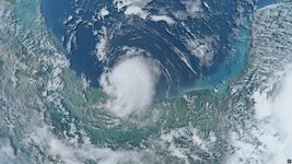
Yes, absolutely. I was finally able to make the level 10 version of the hurricane version and it went quite well. But I think the sweet spot will be at level 11, that's where it should really look good. I'm not super excited to make all the level 11 tiles, because it's a lot of work, but I think it'll be worth it.I think it's pretty enough to have level 10 (and maybe 11) for global cloud textures.
Here's an image of the level 10 version:
.jpg")
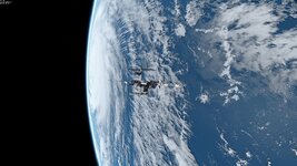
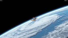
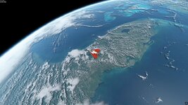
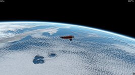
You see that in general, it looks very good but there's still issues with the resolution and clearly pixelated areas. In the upper right corner you can also see that it gets much better once we get around 800-1000 km away, so level 11 should do the trick for a distance of ~200 km.
You're absolutely right again! There are some areas that look really good already and upscaling with an AI-based tool went really well. But unfortunately there are a lot of areas where the clouds are so low resolution that upscaling doesn't work properly and I'll need to replace these areas with better imagery. This will be a huge task unfortunately, I won't be able to do that quickly by any means, because it is a problem in very large areas and the satellite imagery at this high resolution always comes in patches. That means a loot of photoshop sessions. But it will be fun anyway because I want to include as many different cloud features as possible and working with that is alwas fun.but not for the whole cloud map, but for some areas, namely editing cloud map locally.
You got me, this did happen.Also, don't forget to "set MaxCloudResolution = 10" in "Earth.cfg".

The problem with all these tools also is that there's no child lock and if you enter one wrong number, the whole thing may fail, which gets more frustrating the more work you have to put into a new version.
Yes. The image size is restricted but you can still create the folders for all levels. I have the same bottleneck in my AI-upscaling software, it can also only make a 32000x16000 image, which almost matches a level 9 global map, so for level 11 I have to work with 16 tiles for the whole Earth. This also complicates the insertion of new imagery a bit, it seems it will be like a puzzle with not so many parts but with many knobs on each piece.For me the restriction of using "plsplit64" was in the size of a BMP image that I used as the cloud map source, but it wasn't the restriction of "plsplit64" inself. So I cutted the source map at big tiles and used "plsplit64" for them separately. I asked it above and the answer is "yes".
So, "plsplit64" creates the correct folder and tile names for tiles of level 10 (and higher, I suppose).
YES!!!

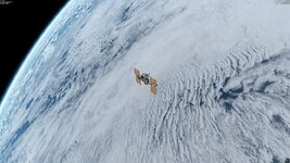
Here's some pictures of the level 10 looks that in my opinion are pretty awesome already. You have to look quite closely to see some pixelated areas.
.jpg")
.jpg")
.jpg")
Last but not least I think that of course personal taste of what you want to look at will be different. I like all kinds of clouds and mostly, I just want to look at interesting stuff that happened in the real world.
Last edited:

")
.jpg")
.jpg")
")
.jpg")
.jpg")
.jpg")
.jpg")


.jpg")
.jpg")
.jpg")
.jpg")
.jpg")
.jpg")
.jpg")
.jpg")
.jpg")
.jpg")
.jpg")


.png")
.png")


 ) to work a bit on an update to the high res cloud layer to increase high quality coverage and add some new features. In particular I wanted to try to make use of QGIS for that as well.


.jpg")
